The land that would become Cambridge held villages housing the Massachusett, and was used by them and other indigenous peoples dating back thousands of years; it was first occupied by European newcomers in 1630, dispossessing the indigenous peoples. For its first eight years those Puritan settlers called the area Newtowne (or “New Towne” or “Newe Towne”). The top men in town were all graduates of the University of Cambridge in Cambridge, England, including the John Harvard whose contributions led to the founding of Harvard College in 1636. Smart they may have been, but not very original; when they chose a name to replace “Newe Towne,” the name was Cambridge.
Cambridge was finally incorporated as a city in 1840, uniting the rival villages of Cambridgeport, East Cambridge and, uh, Old Cambridge, but some would argue the city never lost the feel of villages uncomfortably coexisting. The ongoing and halting construction of the residences and offices of NorthPoint, 45 acres bleeding into Boston and Somerville, is only the latest example of this — albeit one that highlights and exacerbates, rather than ameliorates, the problem; the development will be served by Cambridge’s sole stop on the green line, which will be moved closer to it and farther from the rest of the city, and isn’t even named sensibly; it’s in East Cambridge, and nowhere near the existing North Cambridge.
Over the years Cambridge has been a leader in an ever-changing parade of technologies ranging from bricks and ice to Polaroid instant film. Its current specialties are high-tech, biotech and alternative energy. But Cambridge has also grown to be dominated by another specialty: higher education. Harvard College has grown into Harvard University, which has swelled across the Charles River into Boston and Allston, and overlaps here with the Massachusetts Institute of Technology (moved from Boston in 1912) and Lesley University. Already ethnically diverse from immigration patterns over the centuries, Cambridge has been further diversified as a center for learning. Local government boasts that more than 50 languages are heard on city streets, and residents have the benefit of cuisines from Afghan to Tibetan and everything in between.
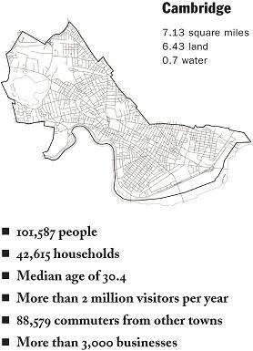
With 15,766 people per square mile in 2000, it was the second-most densely populated community in Massachusetts (behind neighboring Somerville) and the 10th-most in the United States, and as of 2010 the figure has risen to 16,355. The U.S. Census estimated that, as of 2007-09, the median household income was $88,238, but about 15.4 percent of the population was below the poverty line. Although Cambridge is famed as liberal and heavy on support services, city manager Robert W. Healy Jr., over roughly three decades in office, managed to keep its credit ratings the highest possible. Now that feat is being handled by City Manager Richard C. Rossi.
The city is represented by a nine-member city council whose members select one of their own to be mayor, and there is a six-member School Committee, presided over by the mayor, and a superintendent of schools.

The areas, neighborhoods and squares of Cambridge
According to the 2008-10 American Community Survey, 26 percent of people in Cambridge are in college, and the most recent census shows 65 percent of the city’s housing units are rented. This adds up to an extremely transient population, and it can get confusing for newcomers to parse the various squares, neighborhoods, areas, nooks and crannies claimed by longtime residents. You may be ready to meet a friend in Central Square, or even Inman Square. But are you prepared to find your way to Huron Village or Larchwood?
There’s no real easy way to get into the details, or through them.
City government says there are 13 neighborhoods in Cambridge: East Cambridge; Area 2/MIT; Wellington-Harrington; Area IV; Cambridgeport; Mid-Cambridge; Riverside; Agassiz; Neighborhood Nine; West Cambridge; North Cambridge; Cambridge Highlands; and Strawberry Hill. (Another version of the 13-neighborhood map, uploaded by real estate agent Charles Cherney with some annotation, is here.)
But city government also calls these Cambridge’s five major squares: Central, Harvard, Inman, Kendall and Porter, even though many newcomers will probably discover Cambridge first through its T stops, which excludes Inman but adds Alewife and Lechmere.
It may not make sense at first, but take heart. Cambridge is only 6.43 square miles and densely populated, so how lost can you get? To get you started getting lost, here’s a guide to how the squares and areas overlap with the neighborhoods:
Alewife is in North Cambridge above Cambridge Highlands, but walk south across a bridge and you’re at Fresh Pond.
Avon Hill is an upper-class neighborhood of Porter Square, which puts it in Neighborhood Nine (also called Area 9) and Peabody — and looks across Massachusetts Avenue at North Cambridge.
Brattle Square is part of Harvard Square to the west, at the complex intersection of Brattle and Mount Auburn streets just above Eliot Square.
Brattle Street is Tory Row, and vice versa, and they’re both an area of large, beautiful and historic homes to the west of Harvard Square in West Cambridge.
Central Square is at the nexus of Mid-Cambridge, Area IV, Cambridgeport (also called The Port) and Riverside. Lafayette Square is attached to the east by Massachusetts Avenue.
Charles Square is part of Harvard Square to the west, a private area between The Charles Hotel and Harvard’s Kennedy School of Government next to Eliot Square.
The Coast is another way to refer to the Cambridgeport neighborhood.
Coolidge Hill is a ritzy area between Mount Auburn Cemetery and the Charles River in West Cambridge.
Deguglielmo Plaza is part of Harvard Square in front of 25 Brattle St., where Brattle Street turns and Eliot Street begins.
Eliot Square is part of Harvard Square to the west, where Eliot and Bennett streets meet just below Brattle Square.
Fresh Pond is the neighborhood of the Fresh Pond Reservoir below Alewife and overlapping with Cambridge Highlands toward the north, Strawberry Hill toward the south and Neighborhood 10 (also known, confusingly, as West Cambridge) toward the east. (And the town of Belmont to the west.)
General MacArthur Square is a small, V-shaped Harvard Square island between Massachusetts Avenue (on both sides, east and west) and Garden Street (to the north) as well as between the Old Burying Ground (to the west) and Harvard Yard (to the east).
Harvard Square is considered to be mainly in West Cambridge/Neighborhood 10, when anybody bothers to think at all about which neighborhood it’s in. But Cambridge Common is in Neighborhood Nine, as soon as you cross Harvard Yard toward the university’s Science Center and Sanders Theatre you’re in the Agassiz neighborhood and plenty of the square fades off to the east into Riverside. It makes thinking about “where” Harvard Square lies, except as its own place, more or less useless.
Harvard Yard is Harvard’s quad and old campus, located to the northeast of the heart of Harvard Square — the plaza and “bunker” providing access to the MBTA red line. Harvard Yard remains surrounded by gates, which can be locked and guarded. They are at times of campus unrest, causing residents and tourists to walk around while members of the Harvard community can walk through.
Huron Village is in West Cambridge/Neighborhood 10, east of Fresh Pond.
Inman Square is arguably in Mid-Cambridge and Wellington-Harrington, blending imperceptibly into East Cambridge to the north up Cambridge Street.
Lafayette Square is attached to the east side of Central Square on Massachusetts Avenue.
Larchwood is the southernmost portion of Neighborhood Nine, above Cambridge Common, West Cambridge and Harvard Square and to the west of the Agassiz neighborhood. Upland Road is its border to the north.
Lechmere is the MBTA green line stop named after a defunct department store that provides access to East Cambridge and NorthPoint.
Observatory Hill is midway between Fresh Pond and Harvard Square, clustered around the intersection of Concord and Huron avenues.
Peabody is another way people have to refer to Neighborhood Nine (also called Area 9), made distinct from North Cambridge only by being south of Massachusetts Avenue.
The Port is how some refer to the Area IV neighborhood.
Putnam Square is the area around where Mount Auburn and Massachusetts Avenue meet on the east side of Harvard Square. The remnants of an informal housewares and furniture district can still be found here.
Radcliffe Yard is south of Cambridge Common on Garden Street, a few blocks northwest of the heart of Harvard Square. The sexes were once separated at Harvard, with women officially attending getting a Radcliffe degree.
Tory Row is Brattle Street, and vice versa, and they’re both an area of large, beautiful and historic homes to the west of Harvard Square in West Cambridge.
Strawberry Hill is a small area that starts mid-Fresh Pond Reservoir and Thomas P. O’Neill Municipal Golf Course and extends south to the borders of Belmont and Watertown, going only as far east as the train tracks.
Winthrop Square is a blocklong park at Winthrop and JFK streets in Harvard Square. It was the site of Cambridge’s first farmer’s market (back when Cambridge was called New Towne, in fact) and next to its Puritan-era jailhouse.

There are nine bridges between Cambridge and Boston over the Charles River. Looking at them from west to east:
The Eliot Bridge connects Soldiers Field Road in Boston with West Cambridge, sometimes known as Area 10, and near the Cambridge Boat Club, Buckingham Browne and Nichols private school and the start of Memorial Drive.
The Anderson Memorial Bridge is where North Harvard Street becomes JFK Street and connects Allston and Harvard’s campus there with Harvard Square, John F. Kennedy Park and the Weld Boathouse.
The John M. Weeks Bridge connects the Harvard campuses of Allston (by Soldiers Field Park) and Cambridge (between Dunster and Leverett houses, with access to the park stretching along the Charles River and the Dr. Paul Dudley White Bike Path).
The Western Avenue Bridge connects Allston by Soldiers Field Park and Cambridge, leading directly from Central Square in the Riverside neighborhood. (Car traffic heads toward Boston and Allston, not toward Cambridge.)
The Cambridge Street Bridge connects Allston (and the Massachusetts Turnpike) and Cambridge, leading directly to Central Square by way of Riverside Press Park. (Car traffic heads away from Boston and Allston, toward Cambridge.) River Street is the border between the Riverside and Cambridgeport neighborhoods.
The Boston University Bridge connects Boston at the start of the Charles River Esplanade and Boston University Sailing Pavilion, as well as Boston University’s campus and the Massachusetts Turnpike, with Cambridge at Magazine Beach, providing access to Kendall Square and the Cambridgeport neighborhood.
The unfortunately named Harvard Bridge brings Massachusetts Avenue from Boston’s Back Bay to Lafayette Square and Central Square by way of the Massachusetts Institute of Technology (and a section of town sometimes referred to as Area 2) with access to its Kresge Auditorium and the famous Infinite Hallway.
The Longfellow Bridge connects Boston’s Beacon Hill with Cambridge’s Kendall Square.
Monsignor O’Brien Highway connects Boston’s North End (including North Station and the TD Garden) with East Cambridge and NorthPoint, including the Cambridgeside Galleria mall. It passes the Museum of Science, which is split between Boston and Cambridge across the river.
Interstate 93 is barely in Cambridge, and access to it is through Somerville and Charlestown; it crosses the Charles at the iconic Leonard P. Zakim Bridge.